
Cook Islands election: Opposition rules out coalition deals as Brown banks on independents
Rashneel Kumar, Cook Islands NewsFri, 31 Jul

Aerial view of the Ha’apai island group in Tonga. The country is mapping its low-lying islands using LiDAR technology to better understand coastal risks from sea-level rise, storms and flooding.
Photo/Facebook/Tonga Tourism
A nationwide survey will give both nations their most detailed coastal data yet, helping them prepare for rising seas, stronger storms, and future disasters.


Tonga is set to map all of its low-lying islands using high-resolution LiDAR technology.
This will give the country its most detailed picture yet of coastal risks as climate change intensifies across the Pacific.
The nationwide mapping effort will be completed in 2026 and will make Tonga one of the few Pacific Island countries with full national LiDAR coverage.
According to the United Nations Development Programme (UNDP), the data will support coastal protection planning, disaster preparedness, and long-term climate adaptation.
A key part of the work will take place between 21 March and 18 April 2026, when a specialised survey aircraft will carry out mapping flights over Tongatapu and the Ha’apai island group.
LiDAR, short for Light Detection and Ranging, is a technology that uses laser pulses from an aircraft to create highly detailed three-dimensional maps of land and coastlines.
The data helps scientists and planners model flooding, storm surge, and sea-level rise: risks that are becoming more urgent for low-lying Pacific islands.
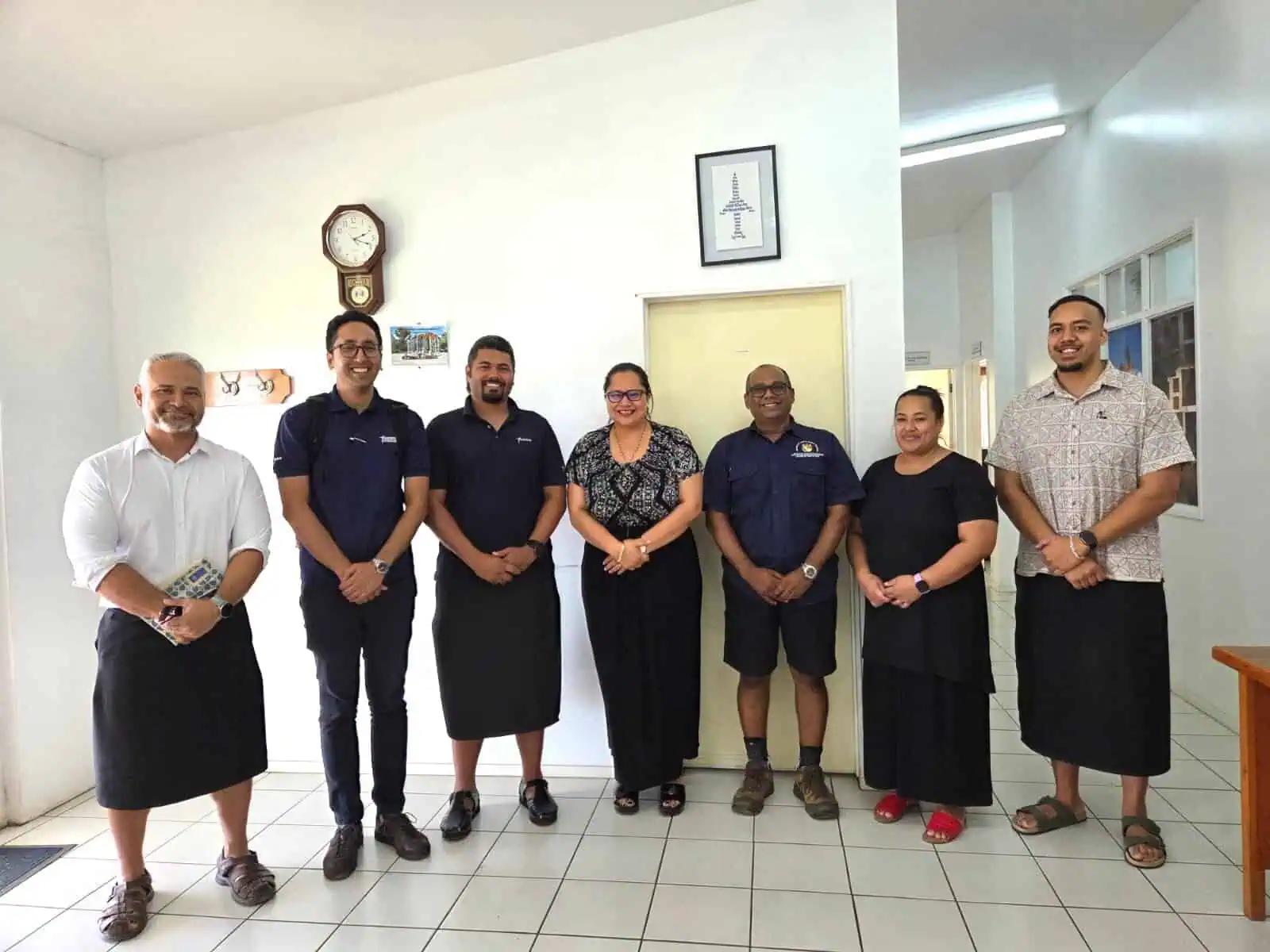
Officials from UNDP, SPC, Fugro, and the Ministry of Infrastructure during preparatory coordination meetings ahead of Tonga’s 2026 national LiDAR survey. From left: Ashley Fua, Hideharu Uno, Michael Brown, Vinolia Salesi, Andrick Lal, Sela Finefeuiaki, and James Panuve. Photo/UNDP
The mapping is being carried out through the Tonga Coastal Resilience Project, funded by the Green Climate Fund, and implemented by UNDP in partnership with the Tongan government.
UNDP says the new dataset will help the country identify areas most vulnerable to coastal flooding and guide future decisions on infrastructure, coastal management and community protection.
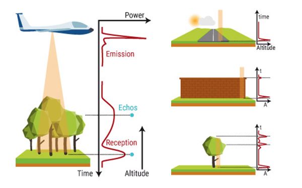
Illustration showing how LiDAR works. Aircraft send laser pulses toward the ground to create highly detailed three-dimensional maps of land and coastlines. Photo/yellowscan.com
The project also aims to strengthen Tonga’s ability to manage and use climate and coastal data.
UNDP is working with the Pacific Community (SPC) to support government agencies in collecting, analysing and applying geospatial information for climate planning.
Preparations for the survey have involved technical coordination between SPC specialists, the international geo-data company Fugro, and several Tonga government ministries.
These include the Ministry of Meteorology, Energy, Information, Disaster Management, Environment, Climate Change and Communications, the Ministry of Lands, Survey, Planning and Natural Resources, and the Ministry of Infrastructure.
During the survey, technical teams from SPC and Fugro will work alongside Tonga’s Mapping and Surveying Division to support knowledge sharing and build national expertise.
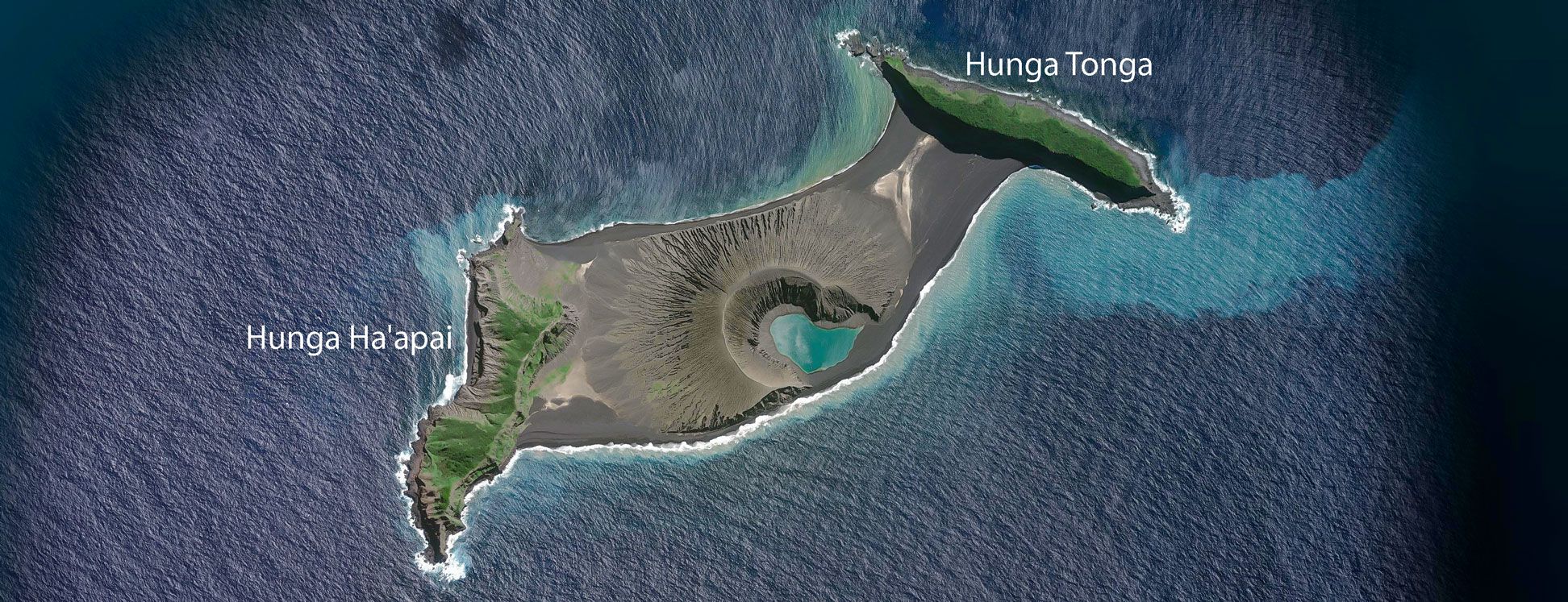
Satellite view of islands in Tonga’s volcanic island chain. Detailed mapping helps scientists model coastal flooding and sea-level rise affecting Pacific island nations. Photo/USGS
Tonga has carried out LiDAR surveys before, but the 2026 work will complete the country’s first full national coverage.
Earlier surveys were funded by the Australian government in 2012, covering Tongatapu and parts of Ha’apai, and by the World Bank in 2021, covering islands including ‘Eua, Vava‘u, Tafahi, and Niuatoputapu.
Once the new survey is complete, the combined datasets will provide a single national LiDAR baseline for Tonga.
According to project partners, the information will allow more accurate flood and coastal inundation modelling and support safer infrastructure design as the country plans for future climate impacts.
For Tonga, the investment in detailed coastal mapping is expected to strengthen long-term planning and help protect communities and infrastructure from growing climate risks.
In the Marshall Islands, high-resolution coastal mapping is also underway where low-lying atolls face increasing risks from sea-level rise and coastal flooding.
The work is part of a regional initiative led by the Pacific Community (SPC) to collect detailed coastal data that will help governments better understand climate threats and strengthen national planning.
The project is supported by funding from the Green Climate Fund and the governments of Australia and New Zealand, with geo-data specialist Fugro contracted to carry out the survey work.
Fugro will deploy its RAMMS airborne LiDAR and imaging system to gather high-resolution information on shorelines, coastal exposure, inundation pathways and future hazard scenarios.
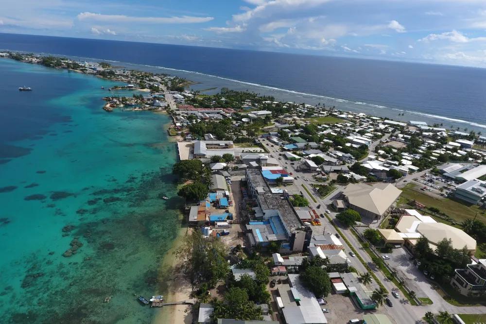
High-resolution mapping is helping the Marshall Islands understand coastal risks from sea-level rise and flooding, part of a regional project led by SPC and supported by Fugro. Photo/https://ocean.si.edu/Monica Palaseanu-Lovejoy
“This investment blends multiple national and regional priorities, bringing together, among others, the Marshall Islands’ Strengthening Manit to Address Loss and Damage project supported by MFAT, and the SPREP-led Weather Ready Pacific programme,” said Hervé Damlamian, Team Leader Oceanography at SPC, in a report.
“It delivers the critical coastal baseline data needed to enhance early warning systems and to enable risk-informed, resilient planning in both countries.”
Paul Seaton, Fugro Director for Climate & Nature (APAC), said that “by deploying RAMMS, we can map hazardous shorelines quickly and with the precision planning authorities require”.
“Just as importantly, we’re investing in local capability, so this knowledge stays in the region.”