

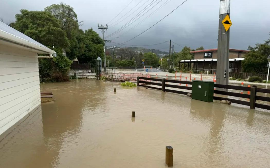
Flooded roads and heavy rain hit parts of Aotearoa over the weekend with more downpours expected as warnings remain in place.
Photo/Supplied
Environment
More heavy rain to hit NZ as flooding risk continues - MetService
Fresh warnings are in place across the country, with MetService saying more downpours are on the way and police urging drivers to stay off flooded roads.
PMN News
Published
19 April 2026, 8:42pm
Share
Copy Link
Top stories

Fiji court stops case, finds anti-corruption agency had breached Charlie Charters' rights
Christine RovoiFri, 24 Jul

Petrol prices could climb above $3 in NZ amid Mideast tensions
Andre Fa'aosoFri, 24 Jul

Expert says one year after landmark climate ruling, Pacific children still waiting for change
Aui'a Vaimaila Leatinu'uFri, 24 Jul
Top stories
Fiji court stops case, finds anti-corruption agency had breached Charlie Charters' rights
Christine RovoiFri, 24 Jul
Petrol prices could climb above $3 in NZ amid Mideast tensions
Andre Fa'aosoFri, 24 Jul
Expert says one year after landmark climate ruling, Pacific children still waiting for change
Aui'a Vaimaila Leatinu'uFri, 24 Jul
More heavy rain is set to sweep across Aotearoa with forecasters warning some areas already hit hard over the weekend are not out of danger yet.
A slow-moving low-pressure system is tracking across the country, bringing bands of rain and heavy downpours to parts of the North Island and the top of the South Island through to Monday.
The latest warnings come after a tough weekend for several communities.
States of local emergency were declared in Ōhura in the Ruapehu District and in Whanganui as flooding and slips forced road closures across the North Island.
MetService has issued an orange heavy rain warning for parts of the lower North Island including the Hutt Valley, Wellington region south of Tawa, Wairarapa, and the Tararua ranges. The warning runs for 31 hours from late Monday morning.
Up to 120mm of rain is expected with as much as 250mm possible in higher areas. In some places, rain could fall as fast as 40mm an hour.
Further south, areas around the Kaikōura Coast and North Canterbury ranges could see close to 130mm of rain by late Monday night.
MetService meteorologist Katie Lyons says the system is being driven by a low sitting west of the country.
Motorists are being urged to take care, avoid floodwaters, and check road conditions as wet weather continues across the country. Photo/Supplied
"As that low - tonight and tomorrow - tracks eastwards, winds will flip around south-easterly and that's why we're seeing those eastern regions like Wairarapa and the Kaikōura coast under those heavy rain warnings," she told RNZ.
"As those winds flip around, we'll get rain continuing there as well as periods of heavy rain. Often, when we get the combination of the longer-lived rainfall with periods of heavy falls, that's when we see those impacts," Lyons said.
She said conditions will vary across the country, with some areas starting to ease while others are still being hit.
"It's quite dependant on where you are. For some places the worst has past but others are in the thick of it - or on the tail end of the thick of it. There's still plenty of severe weather about."
The heavy rain could lead to more surface flooding, slips, and dangerous driving conditions.
Police in Waikato are asking motorists to take extra care with several roads already affected by the weather.
Drivers are being urged to delay travel if possible and to slow down and avoid driving through floodwaters.
Those who must travel are advised to check road conditions before heading out.
As the system moves through, colder weather is expected further south. Snow is forecast to fall on higher ground with a warning in place for Porters Pass where up to three centimetres could settle overnight.
"For the most part, it's just going to be something that people can see once the clouds clear out. It's not really caused much impact, unless they're driving on those higher-level roads," Lyons said. "Just a nice one to see some early snows on the hills,"
Forecasters say people should keep a close eye on updates, as conditions continue to change across the country.