
‘He was our superhero’: The legendary Jonah Lomu’s Tongan story comes to the big screen
Aui'a Vaimaila Leatinu'uMon, 03 Aug

Typhoon Sinlaku batters Saipan with fierce winds and flooding as the slow-moving storm continues to hit the Northern Marianas.
Photo/Facebook/Kel Lajara
The storm has weakened slightly but remains a powerful and slow-moving typhoon, bringing hours of damaging winds, heavy rain, and rising seas across Guam and the Northern Mariana Islands.


A powerful typhoon continues to batter the Northern Marianas with officials warning the danger is far from over as the storm moves slowly across the region.
Typhoon Sinlaku has been downgraded from a super typhoon but it remains a major threat.
Local media reports its slow pace means Guam and nearby islands are facing a longer spell of strong winds, heavy rain, and dangerous seas.
As of early Wednesday, the United States National Weather Service said Sinlaku was still packing winds of up to 130mph.
Guam remains under its highest alert level, Condition of Readiness 1, meaning destructive winds are ongoing.
Heavy rain bands continue to sweep across the island, bringing gusts of up to 70mph overnight.
Winds are expected to ease gradually through the day but damaging conditions are likely to continue into the afternoon.
Flooding remains a serious risk. Inland areas could see flash floods while coastal communities face rising water and powerful surf.
Officials say seas will stay dangerous through at least on Thursday with wave heights already topping 30 feet in some areas.
Residents have been told to stay indoors until conditions are declared safe.
Across the wider Northern Marianas, the storm has already left a mark. The eye of Sinlaku passed over Saipan and Tinian where gusts reached as high as 130mph as the eyewall hit.
Images from the islands show strong winds tearing through buildings and floodwaters covering roads.
The storm is now tracking towards the far northern islands including Alamagan, Pagan, and Agrihan where conditions are expected to worsen.
Even as it weakens slightly, Sinlaku remains a large and dangerous system.
Typhoon-force winds extend around 75 miles from its centre with tropical storm-force winds stretching much further, covering much of the region.
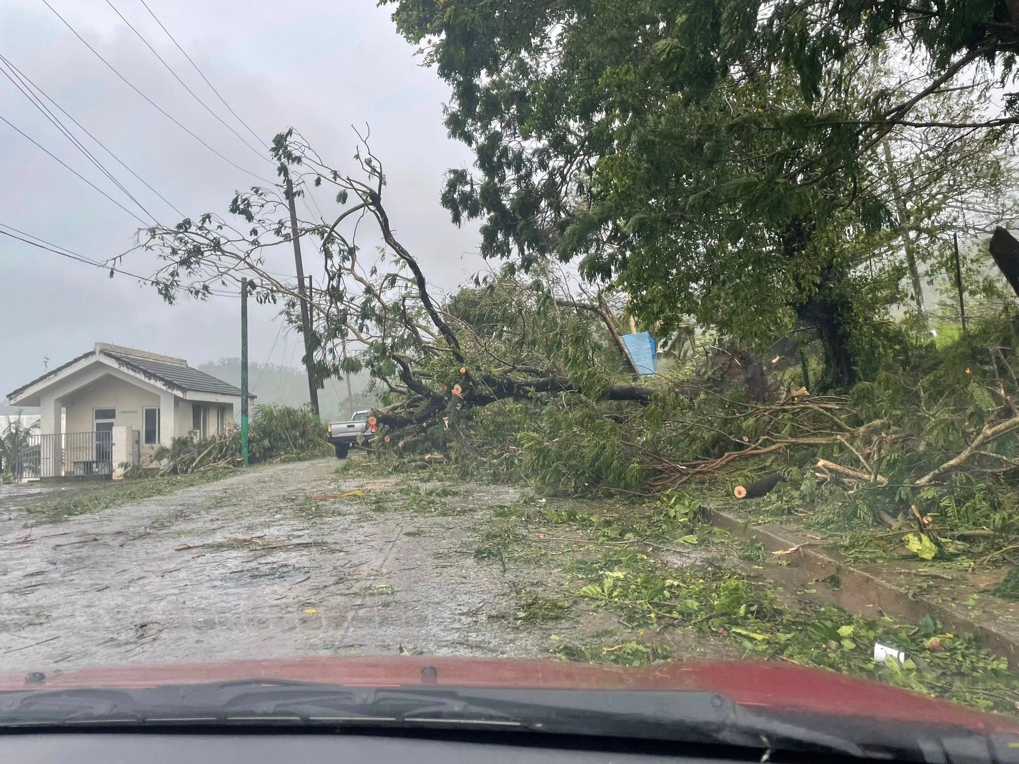
Power lines down and trees toppled in Guam after strong winds from Typhoon Sinlaku swept across the island. Photo/Facebook/Kel Lajara
Guam, Saipan, Tinian, and Rota are all still within this wide zone of wind and rain.
Earlier, Guam narrowly avoided the worst of the storm. At its closest point on Tuesday, the island sat just outside the most intense winds.
Even so, strong gusts knocked out power, brought down trees, and disrupted water supplies across several areas.
No deaths had been reported as of Tuesday night but damage assessments are still ongoing.
Further north, the outlook is more severe. Authorities warned that impacts on Saipan and Tinian could be catastrophic with widespread damage to homes, long power outages, and dangerous flying debris.
The storm has also disrupted travel, leaving at least 1500 visitors stranded on Guam after flights were cancelled.
Sinlaku rapidly intensified earlier this week becoming the strongest cyclone of 2026 so far. It reached peak winds of around 185mph before weakening slightly as it moved across the Pacific.
Forecasters say the system will continue to weaken slowly but warn that heavy rain, strong winds, and dangerous seas will continue across the region for the next few days.
Officials are urging people to keep monitoring updates and follow local advice as the situation develops.