
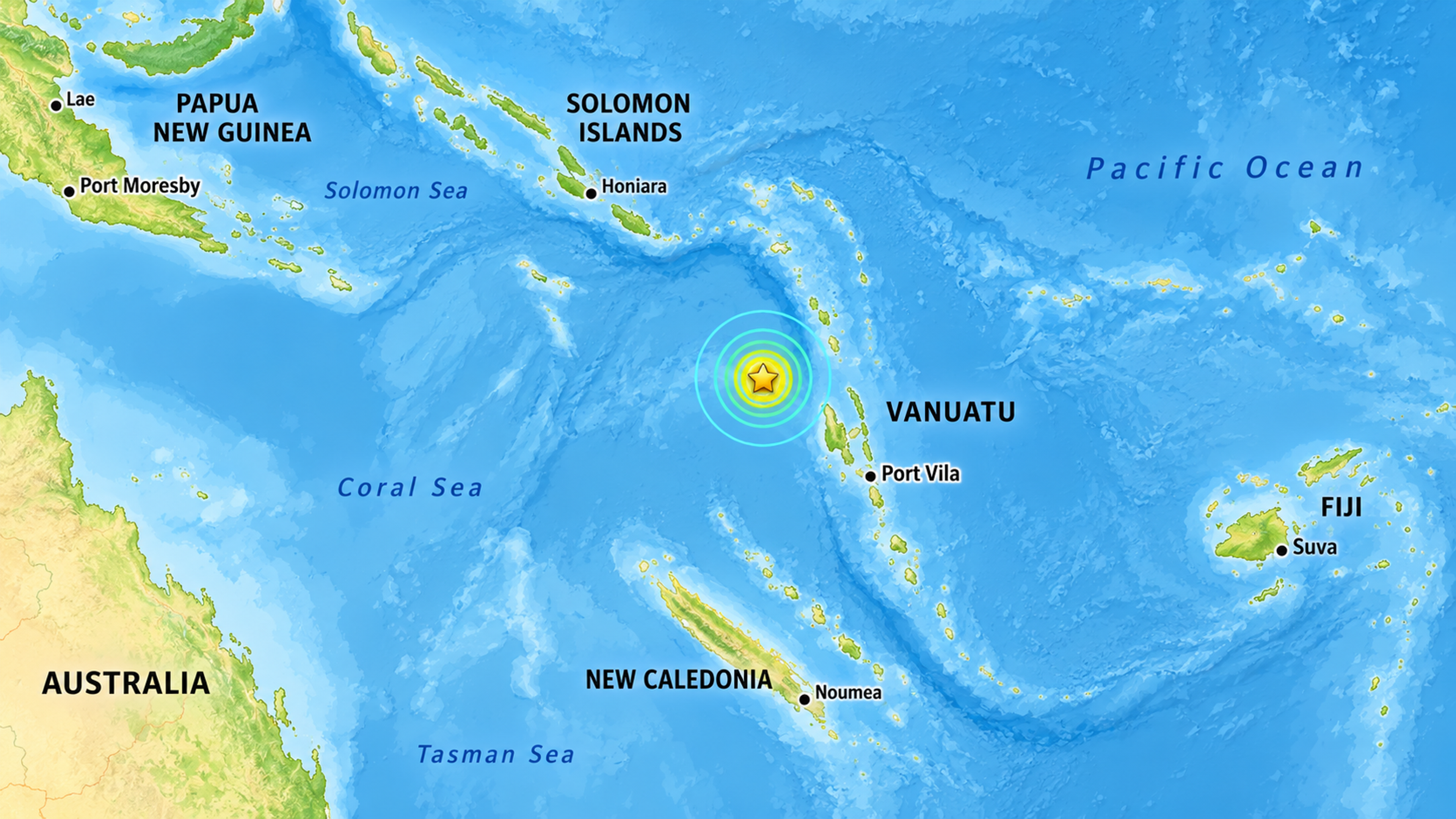
The US Geological Survey locates Saturday's magnitude 6.9 earthquake about 197 kilometres west-northwest of Port-Olry, Vanuatu.
Illustration/PMN News, adapted from a USGS earthquake map.
Environment
Powerful earthquakes continue off northern Vanuatu overnight
Seismic activity continues into Sunday following a powerful magnitude 6.9 tremor, with authorities confirming an earlier tsunami threat has passed.

PMN News
Published
24 October 2026, 3:55pm
Share
Copy Link
Top stories

Fiji's government defends electoral reforms as Law Society warns of ‘chilling effect’
Christine RovoiThu, 12 Nov

Pacific draws a hard line on 1.5°C and says relocation not an option
PMN NewsThu, 12 Nov

Top stories
Fiji's government defends electoral reforms as Law Society warns of ‘chilling effect’
Christine RovoiThu, 12 Nov
Pacific draws a hard line on 1.5°C and says relocation not an option
PMN NewsThu, 12 Nov
UPDATE 5.53am NZDT, Sunday 25 October
More than 20 earthquakes have been recorded off northern Vanuatu since Saturday afternoon, with tremors continuing overnight following a powerful magnitude 6.9 earthquake.
The United States Geological Survey records a prolonged sequence of seismic activity northwest of Port-Olry, including numerous earthquakes measuring magnitude 5.0 or greater.
The strongest strikes at 3.31pm New Zealand time on Saturday, at a depth of 10 kilometres, followed four minutes later by a magnitude 6.3 earthquake.
Several further powerful tremors are recorded throughout Saturday evening, including a magnitude 5.9 earthquake shortly before 10pm.
The activity continues into Sunday morning, with USGS recording further earthquakes measuring between magnitude 4.8 and 4.9.
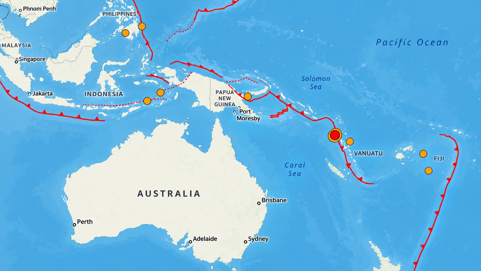
The red circle highlights the magnitude 6.9 earthquake off northern Vanuatu, while the orange dots mark other recorded earthquakes across the Pacific region. Red lines show tectonic plate boundaries. Map: US Geological Survey (USGS), captured 24 October 2026 at 5.11pm NZT..
Vanuatu authorities cancelled an earlier tsunami warning after confirming the threat to coastal communities had passed.
There are no independently confirmed reports of significant damage or casualties, although the impact on communities closest to the earthquakes remains unclear.
The region has also experienced significant seismic activity in recent days, including a magnitude 6.6 earthquake on Tuesday.
UPDATE – 5.56pm NZDT, Saturday 24 October
Three more earthquakes have struck off northern Vanuatu within 14 minutes, as seismic activity continues following Saturday's powerful magnitude 6.9 earthquake.
The United States Geological Survey records tremors measuring magnitude 5.7, 5.8 and 5.3 between 5.05pm and 5.19pm New Zealand time, all at a depth of 10 kilometres.
At least nine earthquakes ranging from magnitude 4.5 to 6.9 have now been recorded in the region on Saturday.
Vanuatu authorities earlier cancelled a tsunami warning following the initial earthquake, but the seismic activity continues.
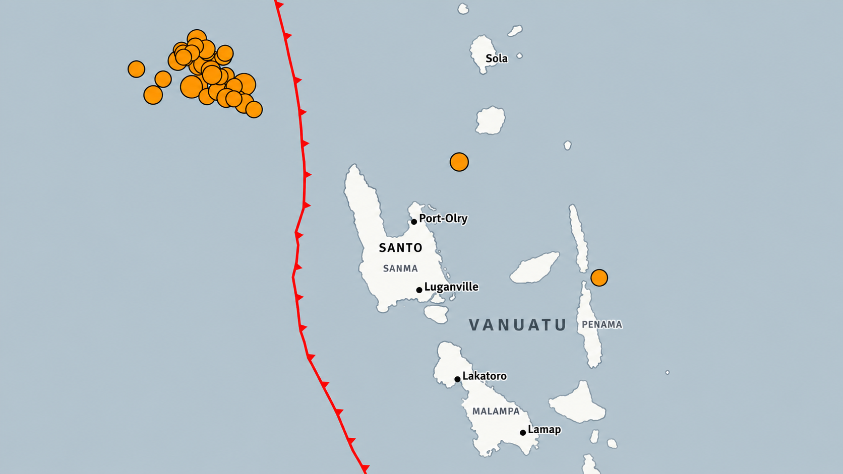
Orange dots mark earthquakes recorded off northern Vanuatu, concentrated northwest of Santo, while the red line shows a tectonic plate boundary. Photo/Map adapted from US Geological Survey (USGS) data, 9.22am NZDT 25 October 2026.
UPDATE - 5.19pm NZT, Saturday 24 October
Vanuatu's Geological Hazards Department has cancelled its tsunami warning following a series of powerful earthquakes off the country's northern coast.
In a statement on Facebook, the department says the latest sea-level observations confirm there is no longer a tsunami threat to coastal communities.
Meanwhile, the United States Geological Survey has recorded another magnitude 4.9 earthquake at 4.51pm New Zealand time, bringing the number of tremors recorded near Port-Olry on Saturday to six.
The strongest, measuring magnitude 6.9, struck at 3.31pm NZ time, followed by a magnitude 6.3 earthquake four minutes later. Four other tremors ranging from magnitude 4.5 to 5.2 have also been recorded.
UPDATE - 4.49pm NZDT, Saturday 24 October
The United States Geological Survey now lists five earthquakes off northern Vanuatu on Saturday afternoon, ranging from magnitude 4.5 to 6.9.
A magnitude 4.5 tremor was recorded at 1.27pm NZ time, followed by a magnitude 6.9 earthquake at 3.31pm and three further earthquakes measuring 6.3, 5.1 and 5.2.
The latest recorded event struck at 4.17pm NZ time.
UPDATE – 4.30pm NZDT, Saturday 24 October
The United States Geological Survey has recorded three further earthquakes off northern Vanuatu following Saturday's magnitude 6.9 tremor.
The subsequent earthquakes measure 6.3, 5.1 and 5.2, all at a reported depth of 10 kilometres.
All four earthquakes have been recorded within 47 minutes, northwest of Port-Olry.
UPDATE – 3.55pm NZDT, Saturday 24 October
A magnitude 6.9 earthquake has struck off northern Vanuatu, just four days after another powerful tremor hit the region.
The United States Geological Survey says the earthquake struck at a depth of 10 kilometres, about 197 kilometres west-northwest of Port-Olry, shortly after 1.30pm local time on Saturday.
Initially reported at magnitude 7.2, the earthquake has since been revised to 6.9.
The Pacific Tsunami Warning Center initially warned that hazardous tsunami waves were possible along Vanuatu's coastline within 300 kilometres of the epicentre.
There are no confirmed reports of damage or casualties at this stage.
This comes only days after a magnitude 6.3 earthquake struck off the coast of Vanuatu on Tuesday, sparking initial concern before disaster management agencies confirmed there was no threat of a tsunami to surrounding Pacific communities.
The undersea tremor hit at a depth of 10 kilometres in the ocean waters northwest of Port Olry, a village on the northern island of Espiritu Santo.
The Pacific Tsunami Warning Centre acted quickly to reassure local authorities and coastal families, issuing a clear clearance following the event.